
Deanside Wetland (known in the scheme as RB3LA/WL2) sits in the base of a retarding basin in Mormac’s residential development at Deanside, in the City of Melton. It is one of the assets in Melbourne Water’s Deanside Drive Drainage Services Scheme, which drains to Kororoit Creek. Working for Mormac in partnership with SMEC, Water Studio prepared the functional design of the sediment basin, wetland and retarding basin, and has supported the project into detailed design.
The brief
A 3.53 hectare parcel had been set aside in the estate for stormwater treatment and flood storage. Into it we needed to fit a sediment basin, a wetland with around 12,900 m² of macrophyte zone, a retarding basin to hold floods above the wetland, and the pits and pipes that decide which flows go where.
The scheme sets a hard limit. The combined outflow to Kororoit Creek in a 1% AEP storm must not exceed the pre-development flow of 5.4 m³/s, so the retarding basin itself can release no more than 3.4 m³/s.
Sending each flow to the right place
A wetland only wants the small, frequent flows. Diversion pits send the 4EY flows (roughly the three-monthly storm) into the sediment basin, which holds them for 12 hours so coarse sediment settles out before the water moves on to the wetland. Larger flows bypass the wetland in a pipe around the southern and western edges of the site, straight to the outlet. There, an orifice caps the release at 3.4 m³/s. When more water arrives than the orifice will pass, it backs up through the water level control pit and fills the retarding basin above the wetland, draining away once the storm passes.
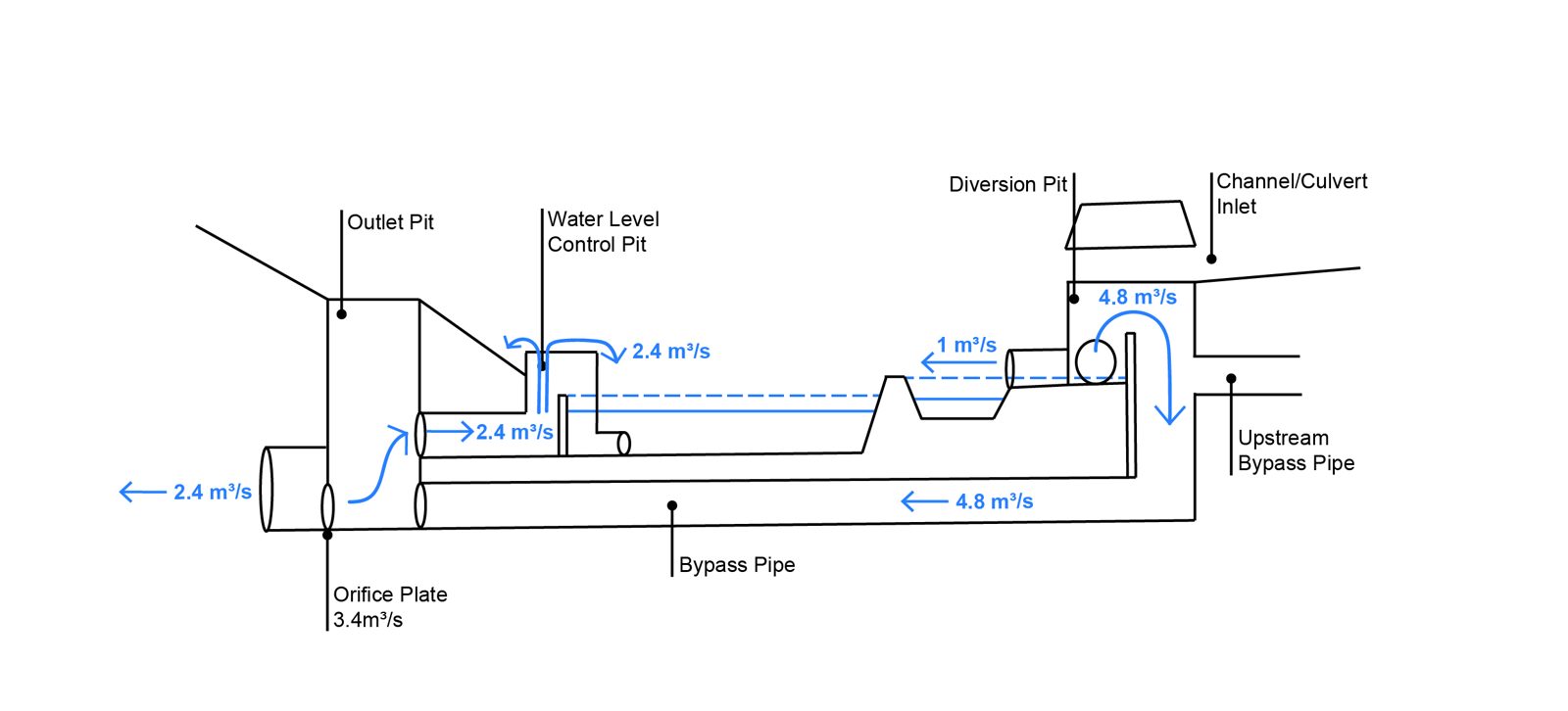
The scheme concept had two bypass pipes, one for flows from the upstream catchment and one for the local estate. We combined them into a single pipe. That removed about 400 m of pipe with only a small upsizing of the main line, and SMEC estimated a construction saving of around $500,000, with less infrastructure for Melbourne Water to maintain afterwards.
We also lowered the whole system by nearly 600 mm. Water now sits in the incoming pipes only while the wetland is in extended detention, rather than permanently, which means less sediment settling in the pipe network and lower cleanout costs for Council and Melbourne Water over the life of the asset.
Designed to be maintained
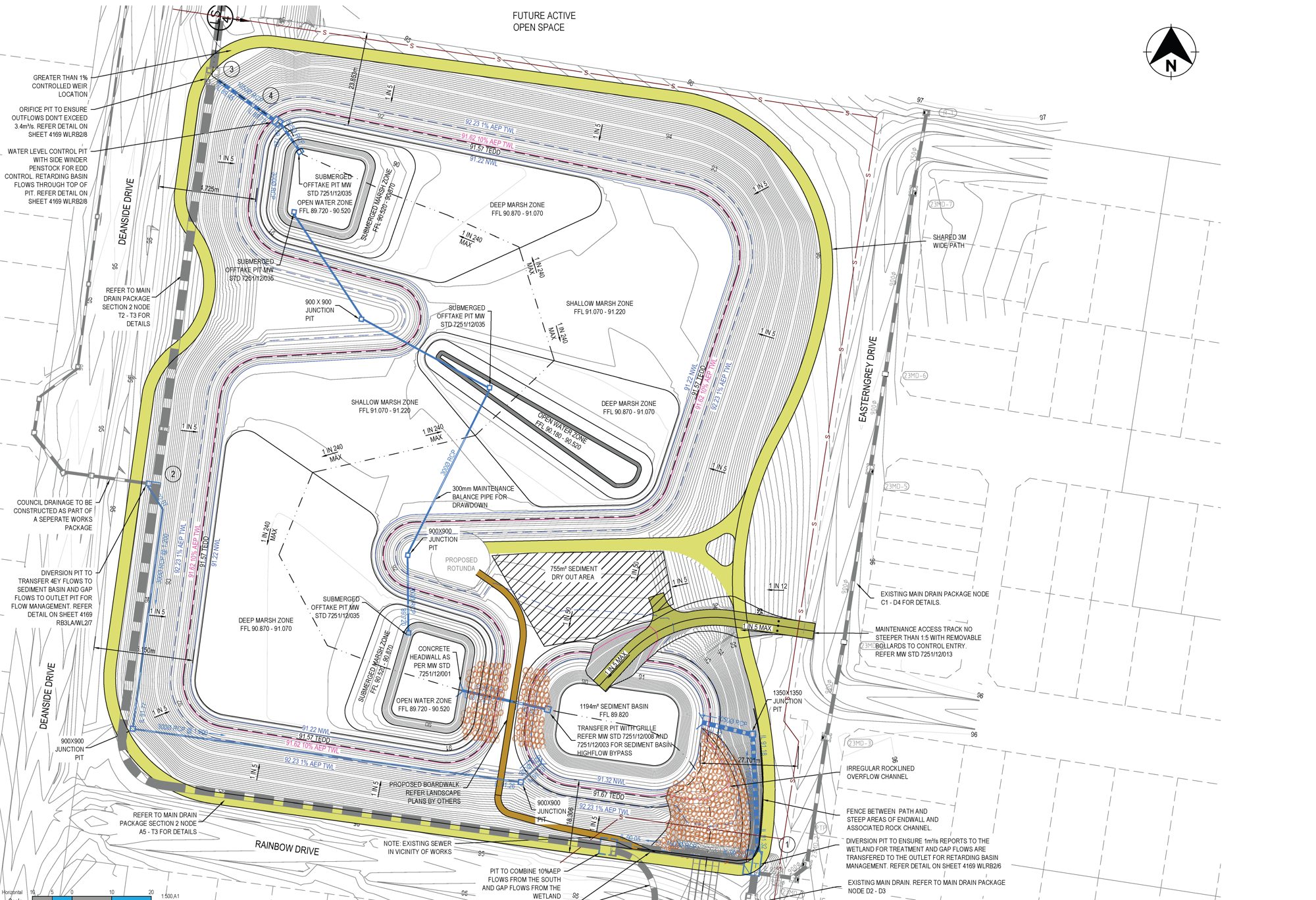
The sediment basin sits 100 mm above the wetland and is hydraulically separate from it, so it can be drained for cleanout without drawing the wetland down. A 4 m wide rock access track, no steeper than 1 in 5, lets a 20 tonne excavator or truck reach the basin, and a 755 m² dry-out area beside it gives the removed sediment somewhere to drain before it is carted away. The base of the basin is lined with a layer of compacted crushed rock: when an excavator bucket hits it, the operator knows to stop digging before reaching the clay liner below.
The wetland is about 320 m long, with bands of shallow, deep and submerged marsh running across its full width so water is pushed through each zone rather than short-cutting to the outlet. Safety benches run around the whole edge, and batters are 1 in 5 or flatter for most of the perimeter. There are no islands, so the planting can be maintained without boats or waders.
The modelling behind it
We updated the scheme’s RORB model with the designed storage and outlet, and ran it under both the original ARR87 methods and ARR2019. The 1% AEP top water level came out at 92.23 m AHD, around 380 mm lower than the scheme had predicted. The MUSIC model confirmed the wetland meets best practice targets for suspended solids, phosphorus and nitrogen. Using the wetland analysis in MUSIC Auditor, we checked how often the plants would be drowned: across ten years of rainfall, the shallow marsh is never under more than 300 mm of water for longer than three days at a time, well inside the ten-day limit. Flow velocities through the sediment basin, wetland and inlet channel were checked in PC Convey. More on our modelling work.
A place for the community
Working with the landscape architects, the asset has been shaped as a park as well as a piece of drainage infrastructure. A shared path loops the basin, a boardwalk crosses between the sediment basin and the wetland, and a rotunda is proposed above the 1% AEP flood level. The inlet channel in the south-east corner is lined with irregular local rock, which slows the water before it reaches the sediment basin and gives the paths an overlook across the wetland towards Kororoit Creek.
The functional design is complete and the project is now in detailed design with Mormac, SMEC and Melbourne Water. See our design services, and how we work with land developers.